Santa Cruz Mountains made sense to me, it was my backyard. High Sierras made sense to me, it is majestic. So where could we go next? I looked at google maps near my house in Sunnyvale, California, and tried to spot the the parks that might be suitable for a hundred mile plus fastpacking adventure. Henry Coe looked promising, but this time of year it can be hard to come across water. But, but, when I looked north, on the other side of the golden gate bridge, I saw this massive expanse of parks from the headlands all the way north to a place called "point tomales" on the northern tip of Point Reyes National Seashore. It looked promising.
The plan was that I would set out to Stinson Beach after Joanne and Hayley's Mermaid run and hike to northern Point Reyes, where I would hook up with Toshi on the next day. And so it happened. It is actually tough to find a parking spot in Stinson Beach on the weekends, it is very much a tourist town. People wanting to hang out on the beach, visit the cafes, chill, go for a hike, whatever. After I found a spot, I set out on the Matt Davis trail to hike up to the Coastal Trail which would in turn take me to Bolinas Ridge. On the way up the Matt Davis trail I ran into Marc, to much of my surprise! He decided to go out for a training run since he had to fly out the next morning. It was nice to have some company on this climb and we chatted things up, how he was recovering from the poison oak from our unnamed adventure from the previous weekend, and how he was getting experience on these trails to get ready for the TNF 50 mile race that is coming up really soon. He followed me up all the way to where I decided to follow a well worn path that diverged from the trail and went straight up the hill. It was a challenging climb, and apparently he got a picture of me in all of my misery after the deed was done. Well, one climb down, many to go. We said our goodbyes and I went off north while he continued on his training run.
 |
| Stinson Beach and the southern tip of Point Reyes from the Coastal Trail. |
 |
| Clear Views all day long. |
 |
| Hang-gliders point. |
I ended up on a road for a while because I went past the coastal trail on my climb up the hill. As I was running I spotted the trail snaking down the hillside, and I knew I would rather be there than on the road, so I started running down the hill. When I did I came across these people that were preparing their hang-gliders to take off of the cliff. They take off from here and land on the coast, pretty crazy! So, naturally, I decided to run down the cliff. It wasn't really a cliff, but a steep hill with loose footing, so pretty much I just slid down the hill until I reached the coastal trail where I continued north.
 |
| Wildlife on the trail. |
 |
| Cool hills seen from Bolinas Ridge. |
 |
| These are the trails that can be traveled on Bolinas Ridge. |
I descended Bolinas Ridge on the McCurdy trail and ran into Point Reyes. It was a beautiful day and I was enjoying the trails.
 |
| It is interesting to come upon trees that seem oddly out of place. |
 |
| Ridge Trail at Point Reyes. |
 |
| Dinner at Glen Camp. Didn't camp here, but there was water... |
I cooked dinner at Glen Camp, the plan being that with less daylight this time of year, I would have to traverse a significant amount of trail in the dark to still hit the mileage splits that I wanted. This meant that I would cook dinner while in the light, and then just hike until I got to my intended destination where I would bivy up for the night. After dinner I continued north and watched the sun set.
 |
| Sunset Saturday night. |
 |
| More sunset. |
It was actually really depressing to hike in the dark by myself. I didn't think it would mess with me as much as it did, but there was something about proceeding in the darkness that made me feel really sorry for myself. I kept thinking about my little kids faces and how much I would like to be holding them at the time, and how much I would like to be in my recliner right then watching Jericho(my new Netflix fix). But I continued on. Every once in a while I would look into the forest and see bright eyes shining back at me, various animals that my headlamp was reflecting off of, but it freaked me out. As I was wandering these trails I started to think about where I wanted to sleep. As I climbed the Drake View Trail, I was passing in and out of young growth pine forests and it made sense to try to find a spot among the trees to sleep. I finally found an opening big enough to sneak off of the trail to find a nice little spot to lay my bivy down. The good thing about sleeping here was that the pine needles were a very nice cushion to sleep on. The bad thing was that every time the wind picked up, the forest made this awful, creepy, screeching sound.
 |
| Slept in a young growth pine forest. Nice padding. |
The next day I felt a lot better. It is funny how sunlight can totally change things. I was hiking up to Mount Vision.
 |
| Looks pretty weird, right? That is a pathway carved into another young growth pine forest. |
 |
| A look at Tomales Bay from Mount Vision. |
 |
| Descending down from Mount Vision. |
Mount Vision had some grate views of Tomales Bay and Drakes Estero. I enjoyed this descent very much.
 |
| A picture of a coastal ranch. |
I then entered ranchland. Basically ranch after ranch, I think mostly dairy farmers.
 |
| Here, ranches become historic landmarks. |
 |
| This is where I set up to await Toshi's arrival. I got a nice little nap in the sun, and took the opportunity to dry out everything. |
Toshi and Judy arrived right at 10 a.m. which was the plan. It was an incredible pick me up to see them and enjoy a picnic of leftover chinese wedding food. It was sooooo gooood. You have no idea. They got some fancy stuff from the wedding, and I gobbled it all down, well not all of it, but I was totally satisfied. It was rather surreal laying out on Toshi's new tarp with boxes of various mushrooms, duck, scallops, etc, and looking over the ranchland that disappeared into the sea.
 |
| Judy was kind enough to let me borrow her husband for another weekend. |
 |
| Toshi, on purpose, tried to disguise himself as a run of the mill hiker. I, on the other hand, decided to show my pride as a "runner". |
After we were done eating, Toshi and wife said goodbye(I didn't put that picture up- it was a bit too hard core for this blog...). Toshi and I were on our way to point Tomales, the northern tip of Point Reyes and the turn-around point for this adventure.
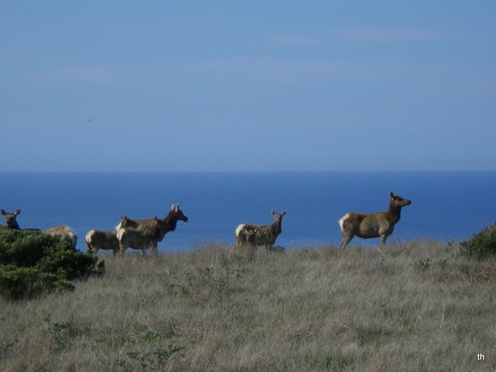
We were now passing through Tule Elk preserve on the northern end.
 |
| Tule Elk. They are protected on the norther side of Point Reyes. |
 |
| This ranch is way old. I think they planted these trees back when it was new, in 1860 something. |
 |
| The alphas were impressive. |
 |
| I don't think this is natural. |
 |
| More beautiful views from the cliffs. |
 |
| Some gnarly trails at point Tomales. |
 |
| Pretty sweet wave action. |
 |
| More views from point Tomales. |
After Tomales Point, we headed south to explore more trails on the southern end of the park. Our next destination before heading back towards Stinson Beach was Alamere Falls.
 |
| Thinking man with a backpack... |
 |
| Toshi was trying to show off for the Elk. They thought his rack was lacking in stature. |
 |
| Pretty weird cricket. |
As we approached the southern side of the park, we decided to explore some new trails near the ocean. Turns out this was a lot more ranchland. Below is a hill we decided to climb to have a nice place to cook dinner and watch the sun set.
 |
| We climbed Devil's Ring-finger where we decided to cook dinner and watch the sun set. |
 |
| Oh yeah. |
It was a beautiful sunset and then we were off into the night. Turns out it is much harder to follow farm roads in the night than what you might think. The cows make their own trails, and they look very similar to the path that was supposed to be the "trail". I really appreciated the company during this night-time hiking, considering my experience the previous night.
It was interesting to try and navigate in the dark, trying to figure out where we were with respect to the maps we had. On more than one occasion we would come to a trail junction and find ourselves in a considerably different location than we had thought. We tried to keep each-other in check while trying to decide which fork to take, but this was an insufficient voting scheme. It would have really helped to have a third hiker to side with one person or the other to make some decisive move and backup our second guessing...
It was just a matter of time before we really screwed up. We followed a trail that dead-ended at a barbed wire fence(like all pasture fences), but it looked like the trail continued on the other side. It didn't make any sense to us though. There should have been a gate, or a sign, or something, that communicated to us to either proceed over the fence, or at least tell us what to do. We noticed a trail that went up the hill along the fence to the north and we took it. As we wend up the "trail", there were several obstacles that we had to get through that told us that maybe that wasn't the trail we were supposed to be on. As we got higher up the hill, and as we consulted our maps more, we realized that we were going in the wrong direction. It was decided to backtrack to the main trail. To the south of the main trail there was a tributary to the "Estero do Limantour". We knew we had to cross it at some point, and thought we remembered some trails going down to the body of water somewhere back on the main trail. So we backtracked even more. After exploring some more in the dark and getting even more muddy from being down by the water, we came to the realization that there was no apparent crossing, so we decided to go back to the dead-end at the fence and see if we could follow the fence south to a crossing. This proved to be another brush scramble that yielded no results, and we ended up back at that dead end. There seemed to be only one option left: take that trail up the hill and see where it went. As we climbed the hill yet again and kept getting higher and higher and farther off of what our maps were telling us, we realized we had to do something else. We decided to jump the pasture fence and headed east towards another hill.
This proved to be a challenge. As we climbed the hill, the brush got worse and worse, more thorns, more things that hurt. We came to yet another fence and followed it south. We finally weaved our way through the brush and onto another farm road. As we followed this road, we thought we were on the right track to converge on the trail, but much to our disappointment, the road just seemed to melt into various cow trails that diverged across yet another pasture. We followed yet another fence south and crawled through some more brush until we ended up in yet another field. This one though was different. The grass was tall, and it was obvious that it was not being grazed. We crawled down and hopped over a creek, and crawled up the other side. As we continued south, thinking that the more south we went, the better chance we had of finally ending up on our trail, things started getting thicker and yuckier. And by yuckier, I mean swamp. Our feet started sinking into the mud and we frequently were stymied by dead ends of un-passable thickets. There were various plants that were stinging us in new ways that we had never been stung before and we were getting tired, cold, and worried about our current predicament. We went in circles a couple of times, looking for that "secret" trail through the swamp, and then we started to give up hope. Finally, it was decided to find a solid piece of ground in the swamp to bivy up for the night and see if we could get a fresh start for the next day.
As we were setting up and licking our wounds, trying to wipe ourselves down just a little bit before we got all of our sleeping gear nasty, the thoughts started creeping into my head. I knew we were totally, and completely lost, and there seemed to be no nice way to get out of where we were. We were surrounded by very unfriendly plants and fences, and we didn't know where to go. It occurred to me that we might spend the whole next day just trying to find some semblance of civilization so that we could limp our way home. It was rather depressing.
 |
| This is where we slept in the swamp. You can't see the cow patty that I am set up on... |
 |
| The Swamp. |
I think we slept pretty good actually. We were really worn out and it was a pretty late night. We awoke to the dawn light, packed up, and made our way out of the swamp to assess our situation. We climbed a hill so that we could get a vantage point and consider our options. When we got to the top of the hill, it became apparent that getting through the swamp was going to be one of our last options. As we scanned around, we noticed a farm road on the opposing hillside, and since it was really the only thing that looked like it was worth walking on, even though it was going in the wrong direction, we decided to see where it went. When we crawled back over to the road, we realized that it headed south around the swamp. This was very good news. We started running enthusiastically, hope reentering our consciousness for the first time in a while. The road then led to yet another gate, but we recognized the road that it connected with, we knew that if we followed it, it would take us back down to the dead end, except the other side of the "dead end". So we went. When we reached that intersection of despair, we spotted several signs that indicated that we were merging with Muddy Hollow Road, the road that we had been looking for the whole time. The signs, and the road, were just around the corner around some bushes, on the other side of the dead end. Below is a picture of the fence that we were expected to jump. We couldn't believe it. But, we got a nice adventure out of it, and we knew we were back on track, so we were happy, and starting to consider all of the fun things that we could still get to that day.
 |
| Are you sure we are suppose to jump that fence? |
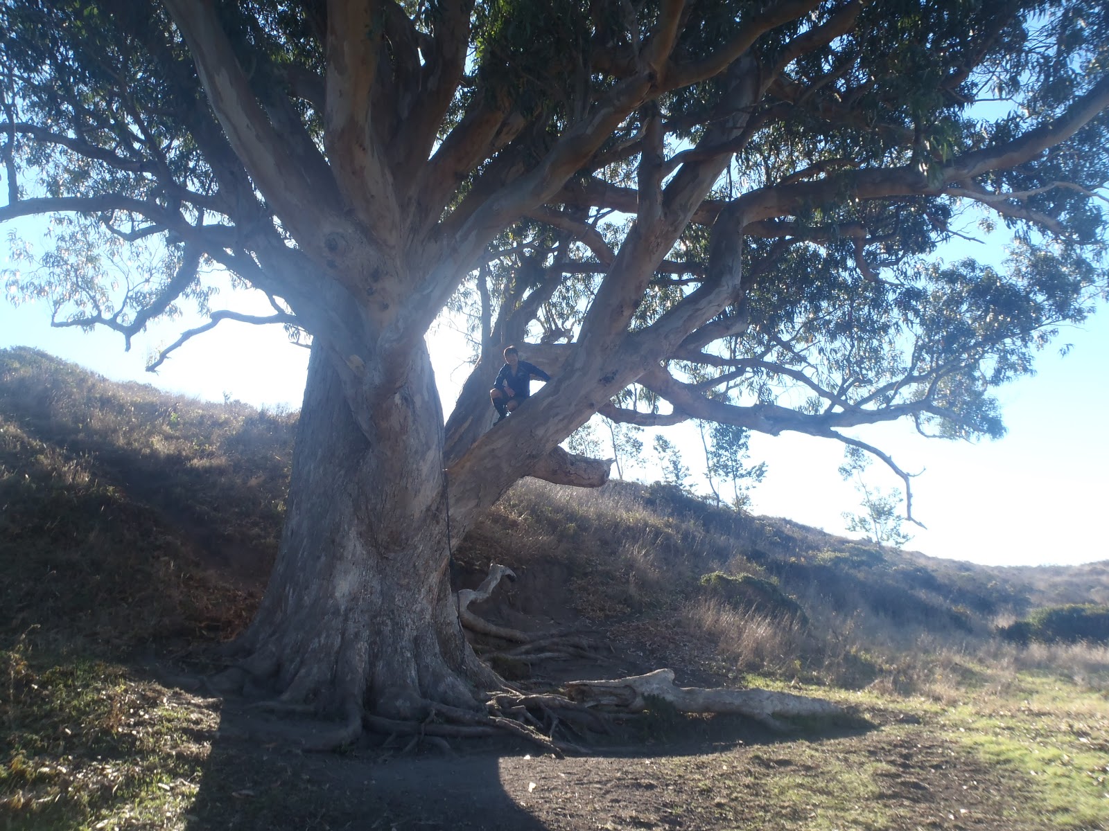
The next leg of our adventure would take us along the coast trail to Alamere Falls, a wonderful waterfall that empties directly into the pacific ocean. The coast trail was beautiful. It just snaked along the hillside along the coast, with clear views of the ocean. We passed a cool backpacking camp, basically right on the coast where there was a single, large eucalyptus tree that Toshi just had to climb.
 |
| Coast Backpacking Camp. |
 |
| Cool Eycolypktus tree at Sky. A strange creature habituating it's limbs. |
 |
| Does it get any better? |
 |
| Arch Rock. |
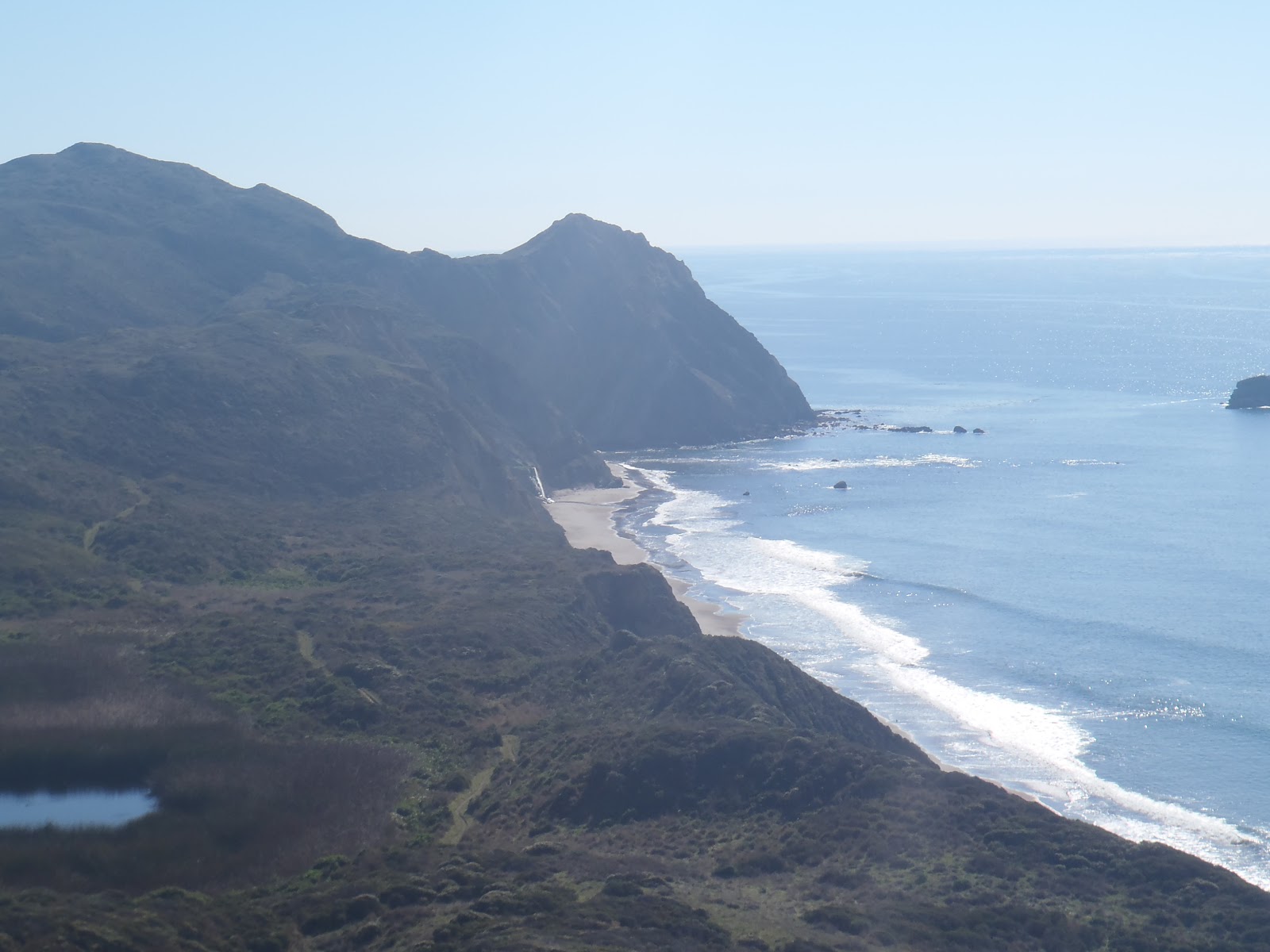
We ate breakfast at Coast camp, and then continued along the coast trail. Along the way we reached "Arch Rock", a pretty cool formation on the ocean. After that, there was a challenging climb up to the cliffs that we would be running along for several more miles before we finally had a big descent down to "Wildcat" backpacking camp.
 |
| Long way down from the cliffs. |
 |
| View from trail down to Wildcat Camp. |
 |
| Can you spot Alamere Falls? |
We spent some time exploring the area around the falls, trying to figure out a way to get down to it. We should have done our homework, we couldn't figure anything out. Turns there were a couple of options, I guess we will have to come back sometime!
Since we hit up all of our destinations for the trip, it was time to make our way home. We were moving pretty good, but knew that we would probably have to finish in the dark before we reached Stinson Beach.
 |
| Toshi and me enjoying our last trail meal together on a bridge. |
 |
| The cool hills again from Bolinas Ridge on our way back to Stinson Beach. |
 |
| Another awesome sunset |
We got back to Mount Tamalpais State Park and the sun was gone by the time we hit the final descent along the Willow Camp Fire Road into Stinson Beach. This was a tough downhill to do in the dark. It was rocky and steep, and my headlamp was just not sufficient for the task, so I took it really slow. But, we finally made it back to town and then spent a while trying to find my truck again(everything looks so much different in the dark). For the last couple of hours of hiking we had been discussing what we wanted to eat when we got back to town(of course). We drove around the seemingly deserted tourist town, until we came across a nice little cafe close to the beach that seemed to be open. When we went inside, we realized that the place was a little bit too nice for the state that we were in. I had wrapped myself in some sweats that hopefully covered up some of the smell, but I am sure I didn't look too good. As we sat down, with lines of drool coming our of our mouths(ok, that was just me), we looked at the menu with dazed eyes. Scallops wrapped with bacon? Some other fancy stuff I can't pronounce... The waitress approached us and Toshi asked if they had cheeseburgers. They said sure, and then proceeded to list off a gazillion different cheeses we could choose from. The waitress got all the way to "Point Reyes Blue Cheese", and Toshi and I knew what we were having. Best burger of my life!
All in all, it was a great adventure. It is actually kind of nice to look back and realize that we had faced adversity, and we came out on top. And that made the experience that much richer. The whole trip was over 100 miles, and I would totally recommend Point Reyes to anyone.


Awesome report! I know you missed me too. ;)
ReplyDeleteYep, I missed you too!
DeleteYeah, I noticed right off you didn't mention missing your amazing wife, only the kiddos and television...but maybe that would have ventured into the 'too hard-core' category.
ReplyDeleteThe description of your swamp experience reminded me of The Hobbit, and Pilgrim's Progress, both of which we are reading to our 9-yr old.
I researched Point Reyes earlier this year, but everything was booked (my family prefers not to sleep in swamps)...it's the next place we've been hoping to go--have to see those elk!
Tell me about it... I realize the reservations are supposed to make things easier, but I don't think it is helping the parks at all. I went through all four backpack camps on my trip and saw plenty of open spots. Yes, someone paid for it, yes, the park got it's money. But I can't believe that "getting their money" is the reason for offering camping spots. There is no way that 20 bucks a spot is paying anyones salary. The top reason for having camping spots should be to fill them up with people, and the current system is insufficient...
DeleteNice little adventure you had there! I love all the pictures too. Man, getting lost sucks! I've been there on a lesser scale, so I can imagine the frustration! Thanks for sharing.
ReplyDeleteGlad you enjoyed it. I think I learned something through the whole thing, so hopefully I am better at making navigational decisions. At least I know more about the trails at Point Reyes!
DeleteYes. It's a good thing too, because who know where we would have ended up if we didn't have it.
ReplyDelete