I can't remember at what point after our trip to Burgdorf last year that my family and I decided that we were going to return this year, but I think it was pretty soon that we started talking about it. It was such a great 100 mile race venue and the perfect family get-away. Oh, and of course, I had unfinished business here.
A couple of weeks out from the race we were informed about a course change due to a couple of fires in the area. Several features of the race were removed and Jeremy (the race director) redesigned the course to include some new destinations and challenges. From what I could tell just reading the online chatter it was going to be a tough but beautiful new course and I was getting excited.
The training had been going well. I took a somewhat radically different approach to my preparation for the race this year, thinking that one of the reasons I had issues last year was that I might have been a little bit over-cooked going into the race with some pretty substantial training that I had done. Last year I was averaging around 300 to 350 miles and 50000 ft of climbing per month for the four months leading up to IMTUF. This year I backed off significantly with only about 200 to 250 miles and 30000 ft of climbing, but also injecting some fun long outings such as the solstice 24 hr and a couple of really fun high sierra backpacking trips.
This year some friends from church, the Valencias: Joel and Kassandra and their two boys Owen and Noah decided to join us in Burgdorf for the fun. We usually plan a trip with them and this year it just made sense to combine our family trip into the race weekend as this is definitely a great place to take the kids and enjoy some new mountains!
Here are some pics of the Burgdorf setup:
Burgdorf in the morning. See the steam coming off of the pool? And the frost? Awesome.
Our cabin: Mary. Joanne's favorite part is the view out the front!
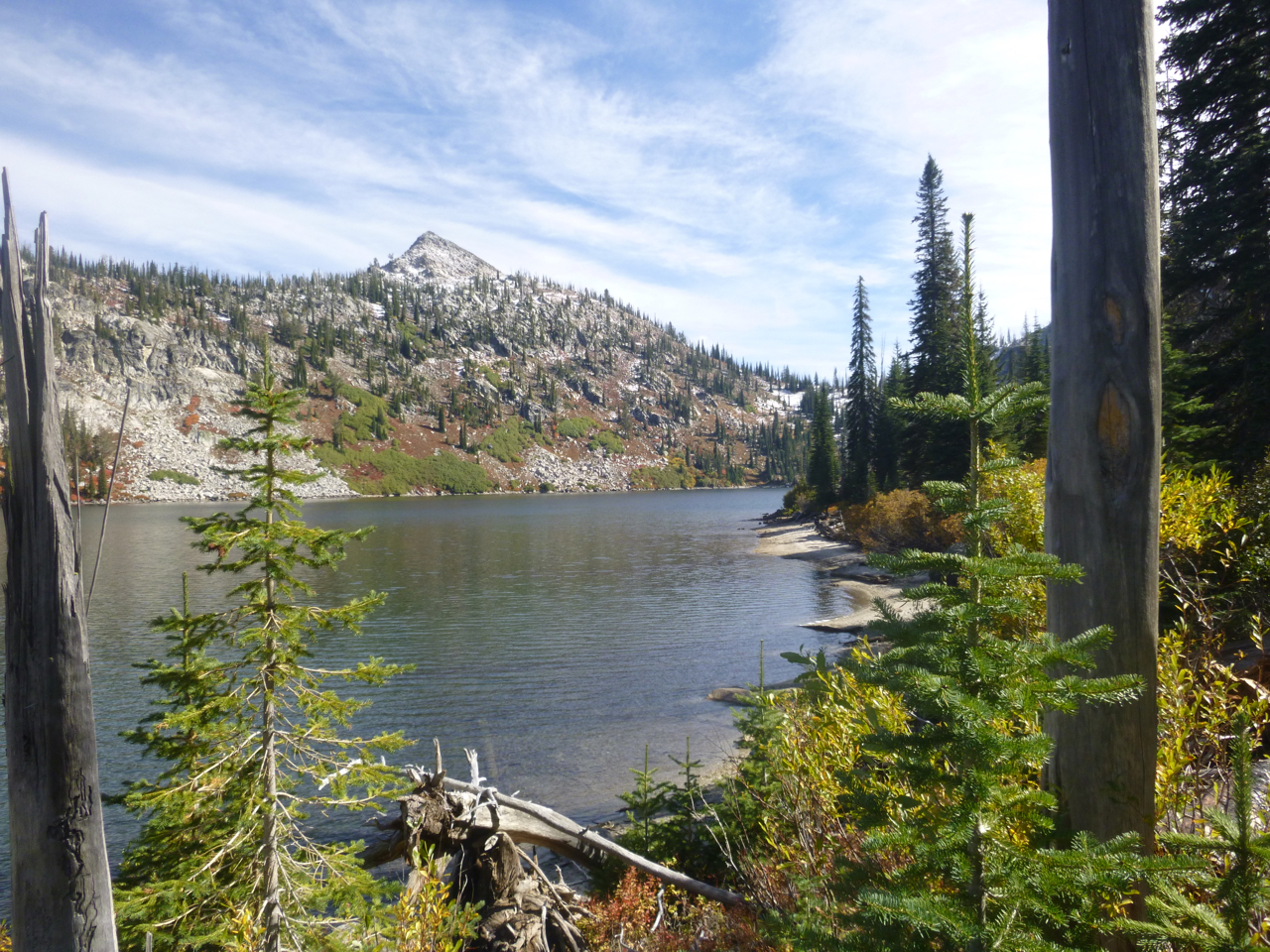
View from the source spring pools. These pools were so hot, you could only last a few minutes!
This is where boys like to play. Drainage from pools.
This is what its all about.
On Friday evening we had our pre-race briefing by the race director duo of husband and wife team of Jeremy and Brandi by the pool:
Pre-race meeting on Friday. Photo by Joanne.
I woke up at 5 a.m. Saturday morning to go to the club house to sign in and get some coffee. Start was at 6. I took my coffee back to the cabin and worked on getting a good fire going for the family to wake up to. While working on the fire, I made final preparations with my running pack and visited the restroom(outhouse in this case - yay). It was getting close to race start and I was still fumbling around with getting the fire nice and hot before I decided to split. As I made my way out the back door I heard the hooping and hollering down at the start line and decided I should probably hustle. As I got closer I heard the countdown and realized I was going to miss the start! The runners took off after the horn was blown but I was weaving through all of the spectators as they turned to go back to their nice, warm cabins. No problem, there is no reason to get anxious about a few seconds in a 100 mile race... I just settled into a nice, easy pace and started catching up with the pack.
The Willow Basket, right as the sun is coming up. This was a highlight both years for me.
I probably got this same pic last year: looking down into the valley we just climbed up from going to Diamond Ridge.
One of the biggest treats at the race this year for me was snow on the high passes! It was such a trip to hike up higher and higher and see the snow up there and then all of the sudden you are in it - making snow-balls, eating it, putting it in your hat - I think this is still technically summer, right?
Other side of Diamond Ridge.
Jogging down to Upper Payette Lake aid station. Crew in tow. Credit: Joanne
As I ran down the hill into the Upper Payette aid station at mile 24 I knew to expect the whole crew to be there to cheer me on. It was pretty funny and chaotic as there were literally children everywhere trying to chase me down the trail. The video at the end kind of captures this mayhem. Joanne was extremely helpful in getting me set up with all of my stuff and getting my on my way. I got to do hugs and high fives with the kids and catch up a little on what kind of fun they were having with the day so far.
The whole crew!
One of the "upper" Payette Lakes.
The real Upper Payette Lake.
I had kept hearing about this thing called the "Terrible Terrence" trail. I suppose it was some kind of a game trail/sheep trail that was usually pretty brushy and hard to follow and not really much fun to travel on, but sort of the most efficient way to get us up to the fire road that took us to the crestline trail - which is where Jeremy really wanted us to be. Fortunately, or unfortunately, depending on how you look at it, the sheep that graze this land had already been through the area and mowed down the grass, making it much easier to navigate. But instead of grass, there was poop everywhere! Oh well -this section didn't last too long. Pretty soon we were dumped out onto the fire road which was this annoyingly moderate pitch that was completely runnable if I wanted to wear myself out for a 100 mile race - so instead I put myself into fast hiking gear and cruised my way up to the crestline. The road itself wasn't much fun - but the views were incredible!
Views while climbing the fire road up to the crestline trailhead.
The crestline.
Incredible meadows up on the crestline!
Alpine lake up on the crestline.
I had met this man named Tom Sawyer up on the crestline and shared several miles with him. He is ex Army who was in Afghanistan and New Orleans. He showed me all of the trees that he had cut out with his chainsaw prior to the race so we could cruise the trails (he is a local who is also an ultra-runner). The crestline was really spectacular and Tom was telling me all about it. About the big fire in 95 that took out most of the trees, about the trout that were dropped into all of the high alpine lakes by helicopter back in the 80s (and were as big as your arm now). And then he told me that some day he would like to make the trails to Box lake stock passable. I didn't realize what he was communicating with me at the time, but we were suppose to be climbing up to Box lake and then up to the pass and then 3.5 miles downhill down the other side - what he was telling me was that you wouldn't want to load up a horse and go on the trails that we were about to tackle. Nice. Man those trails were tough. Usually I can make up a lot of time on the downhills in races, but I was trying to move as efficiently as possible down this mountain and then I would look at my watch and realize I was running 15 minute miles - that's basically like fast-walking pace! There would be these large step-downs where I would plant my hiking poles ahead of me to absorb some of the energy and take the pounding off of my legs. Then you would have to hop some rocks and then do a 160 degree turn at a switchback and repeat. It just went on forever. I finally reached the dirt road that would take me to the infamous snowslide trail where we were routed to go up and over snowslide pass, then down the lake fork drainage but then routed back up to Maki lake and return to snowslide pass only to then go back down to where we started - a lollipop loop. Sounds pretty straight forward - but this loop represented some of the toughest 9 miles of trail I have ever done!
Views of Box lake from the south.
Box from the north.
Box from the sky. I mean the pass. Snow = Awesome.
The valley and the 3.5 mile downhill that I never saw coming!
I reached the Snowslide aid station at about 5 p.m. Not a good thing since I told my family it would be around 6:30. I decided to soak my legs in the cold stream to get them cooled off before the big climb. The family was no where in sight and I decided to push on. It was on this climb last year that my race pretty much fell apart for me. This year I was had saved some legs especially to get me through this and probably the main thing that helped me this year was the cooler temps!
Snowslide climb.
Snowslide Lake.
Looking down at Snowslide Lake as I am climbing to the pass.
Other side of Snowslide pass.
Example of the Maki Lake "trail". Notice the pink flag in the tree. Yes, this is the trail.
Prior to the race I had downloaded the IMTUF course map tiles to my Gaia GPS app on my phone just in case I thought I might need the extra navigation support. I decided it wasn't necessary as the course marking was pretty much immaculate. I did remember reviewing the trails and recognizing the trail up to Maki lake and over to snowslide, but on race day this "trail" seemed much more like a bushwhack and some sadistic race directors idea of creating a lollipop loop where no such loop actually existed. Oh well, it's these kind of trails that spice up the events. I actually enjoy a little bushwhack when no poison oak or thorns are present.
It got dark during the climb up to Maki so I flipped on my headlamp. Pretty soon I was solely navigating by the reflective tape on the course flags tied to the trees. It was all good though - some really steep climbing, but eventually I got myself back to snowslide pass and buckled up for what was sure to be a downhill slip-n-slide to remember...
Going down snowslide in the dark was an exhilarating(?) experience. Much of the time I was just trying not to fall forward and impale myself on the copious rocks. I was also trying to be careful not to kick rocks down the hill for fear of taking out other runners. It was a slow process, but I eventually got myself back to the snowslide aid station where I made sure to thank Jeremy for his wonderful work on the creation of a truly entertaining race course.
The next miles were pretty boring in comparison, just a hike up a dirt road. But it was a welcome reprieve from the fear of destruction that I had been dealing with for the previous 3.5 hours. After the Duck lake aid station there is a nice cruiser of a trail all the way to Upper Payette Aid #2 at mile 67. Well, it would be cruiser if not for all of the roots and rocks and brush. But at least it wasn't steep. I remember kicking a lot of stuff through this section, but generally making pretty good forward progress.
When I got to the aid station I was shocked to see my buddy Joel waiting for me. At 2 a.m.! He had hatched a plan to surprise me with some goodies. It was a nice boost to have him help me out at the aid station: he changed the batteries in my headlamp, got me set up with a bottle of coke to get me through the night, catered to my needs, helped me figure out where to go when I was ready to leave the aid stations - it was great -thanks Joel!
The next climb back up to Diamond Ridge was probably the toughest part of the race for me. Yes, I know I talked about some difficult trails already, but this climb just hit me at my weakest time and it was such a bruiser of a climb. Not really technical or super steep, but it was just a relentless, exposed hill climb in the middle of the night and my energy reserves were gone. I eventually plodded my way up and over the pass and then kicked more stuff all the way down to the special goat aid station. This super friendly couple pack in a bunch of supplies on goats to this remote spot in the middle of the mountains just to offer some key support to the IMTUF racers. I sat down in a chair next to their fire and got some hot soup and resupplied for the journey ahead. The nice lady wouldn't let me leave without getting a picture of me with one of her goats though. I reluctantly agreed - not being a huge fan of intimate poses in the middle of the night with large animals with horns - but I couldn't let her down! The picture is floating around facebook somewhere - you can tell I am not entirely comfortable with the situation...
I stumbled down the mountain some more, running through a couple of streams and started to get thoroughly cold. The sun was supposed to start coming up at any moment now, but man I was really hoping to get a mental boost from some extra light! The problem was that while daylight did come, I never did get to see the sun for quite a while because of being holed up in the valley. So while I knew the sun was there I was still practically freezing. I got to the next aid station and spent way more time that I should have trying to de-thaw by the fire. At this point I was picking comfort over performance - but I figured it was all part of the journey. Just get through the tough 100 miles and pick your style - and at this point I was completely fine with getting fully recharged at the aid stations.
The next morning.
Loon Lake.
The final 20 miles were a grind. The terrain was pretty easy to travel on with some really nice views, but I could care less by this point - I had the "get-it-done" mentality. My running legs were pretty much kaput as well, so I was moving pretty slow. Also, I was done with gels and other sugary aid station food, I just didn't want to stuff any more down my throat and knew I could finish without doing it. I was just fantasizing about a steak and a nap.
Fortunately those miles finally did pass and I rolled down the dirt road to Burgdorf when about a quarter mile from the finish line my family popped out of the forest to pace me in! Then as Ada and I rounded the corner for the final straight-away - the Valencias were there to cheer me on and catch some video of me:
Finish Video by Joel:
Done. And I have the belt to prove it.
My final time was 31 hours and 36 minutes. I think I covered like 101 miles with 17000 ft of climbing. It was everything I could have hoped for - exactly what I signed up for. I am thankful for my family and the Valencias designing their vacation time around my race and supporting me to the end! I would also like to thank Jeremy and Brandi for putting on such an incredible event in their home mountains for no other reason than to share their passion for their land with other ultra-runners. And finally - a shout-out to the army of volunteers (and their goats) who take away from their free-time to make such a silly endeavor possible for us runners. There is no money in this - just a venue for expressing ourselves...whether through pouring out our guts on the big race day culminating from months of preparation, or through self-less giving to enable the runners to fulfill their dreams.
The Evolution Lake Loop isn't actually a loop. It's more like a horseshoe starting at North Lake, traveling over Piute Pass, then descending to a junction with the JMT, then ascending to the Evolution Valley and Lakes, crossing Muir Pass, descending to Big Pete Meadow, then climbing up and over Bishop Pass and ending at South Lake. The whole route is at high altitude ranging between 8000 and 12000 ft with three high passes of Piute(11423 ft), Muir Pass(11955 ft) and Bishop Pass(11972 ft). There are long 3000+ ft climbs and descents that showcases some of the best of the high Sierra.
Sachin and I set off from North Lake at 10:30 a.m. on Saturday. Toshi devised his own loop, starting from Lake Sabrina and traversing cross-country over the Echo Col and bagging an assortment of peaks near Muir Pass where he was going to rejoin us Sunday afternoon to finish the loop up and over Bishop Pass.
Our Evolution Lake Loop. We added in a trip to Muir Ranch and Blaney Hot Springs. Yello and Blue was day one. Pink and Green was day 2. Purple was the last day. This was from Sachin's GPS data. Thanks Sachin!
Start Pic: North Lake.
The climb and descent from the 11423 ft Piute pass was actually pretty mellow. This was a nice reprieve from the day before and allowed us to get into cruise mode and effortlessly tick away the miles as we made our way to the goal for day 1: taking a nice long dip in some natural mountain hot springs before camping for the night. At first Sachin was apprehensive about taking the six mile (roundtrip) detour from the classic lake loop just to perhaps find some hot springs to partake in. Sachin is very goal driven, and when he sets his mind on a certain goal - anything that doesn't get him closer is just more of a hindrance. I tried to make it clear that the out and back was part of MY goal so he grudgingly incorporated it into his goal as well ;-) Another reason for the out and back was to check out Muir Trail Ranch. I always wanted to check the place out as it will be my resupply when I some day tackle the JMT thru-hike. And it just so happened to be a few miles off of the loop that we were planning on...
Valley: looking down at where we started.
Looking East from Piute Pass. Credit: Sachin.
Looking West from Piute Pass.
At Piute Pass we talked with a couple of hiker/fisherman and they were warning us about the smoke from the Rough fire that was hazing the place over. They pointed down into the valley in the picture above and said it was just starting to move in. Their contention was that the mornings were usually pretty clear and then the smoke would drift in during the afternoon only to clear up in the evenings again. Our experience seemed to be mixed. The smoke did seem to ebb and flow, probably most directly influenced by the prevailing winds, but there was never a strong odor - it mostly just affected the views. Which was too bad because we missed out on some awesome pictures.
Once we got down into the trees - this is what it looked like.
Beautiful flowing Piute Creek.
Muir Trail Ranch. This is the strategically placed stop-over halfway on the JMT where hikers mail 5 gallon buckets with their re-supply for the thru-hike.
This is the bear proof shelter where the food resides.
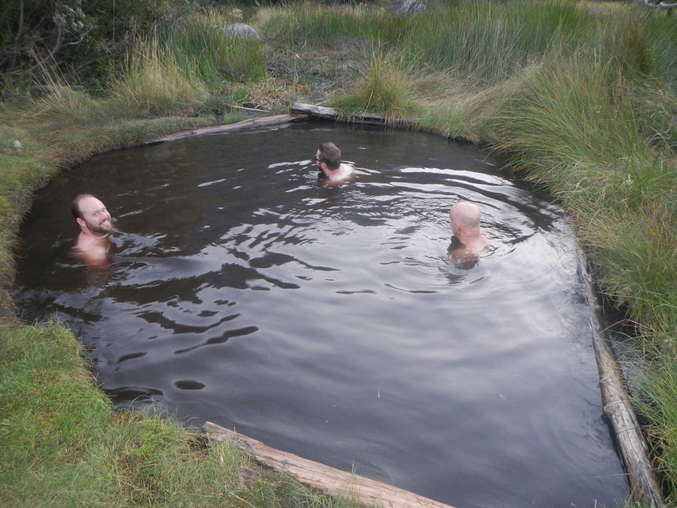
We made it to the junction with the JMT at about 16.5 miles and then traveled north and then followed the cutoff for Muir Trail Ranch which was another 3.5 miles and then another .5 miles to the hot springs. So it actually turned into an 8 mile roundtrip detour. But since we found the hot springs, it made it well worth the trip. The hot springs was not easy to find. There is the popular Blaney Meadows campground, but then you have to cross the river and follow a secret path to find the springs. The pool was about 3 or 4 ft deep which meant that you could relax pretty well in a crouched position. It is a muddy bottom except for where the spring water actually comes out of the ground. There there was a sandy divot where you could feel the hot water with your feet. The pool wasn't too hot, but right where the water came out was cookin'. Sachin and I shared the pool with the three guys in the picture below and had a very relaxing soak while the sun started to go down with views of the valley walls all around. I think Sachin would agree that it was worth it...
After the springs we decided to do a little night hike to regain most of the out-n-back to get closer to the classic loop for the next days journey. During this night hike we managed to cook and eat our dinner as well so by the time we picked our camping spot we were ready to just roll out our stuff and pass out.
The Blaney Meadows Hot Springs.
Next morning following the San Joaquin River upstream towards Evolution Valley.
As we got moving the next morning we knew that we had to be on our game to reach Muir Hut to reconnect with Toshi. We had 18.7 miles with almost 5000 ft of climbing to get done by mid-afternoon. I had told Toshi we were shooting for 2 p.m.
Climbing beside the beautiful rapids of the Evolution Creek.
Crossing a low Evolution Creek. Had managed to keep the shoes dry to this point and the feet were thanking me. Credit: Sachin
Evolution Meadow.
First views of Evolution Lake.
A convenient way to cross the creek. Credit: Sachin.
Lake Wanda. Almost to Muir Hut. Credit: Sachin.
Almost to the hut. Credit: Sachin.
Note that Toshi left at Muir Hut. It took him a little longer than planned. Credit: Sachin.
Seeing Toshi from the hut. He just got done climbing Mt Warlow(pictured in the background)
The gang - back together. Credit: Sachin.
We ended up reaching the hut at about 2:30 and then Toshi got back from climbing Warlow just before 3. So, not bad, all things considered. This was also where a kind hiker woman was attempting to get the perfect photo of the hut. She asked me to move out of her picture frame to obtain said picture. I cooperated, but then she indicated that she didn't want my backpack in the picture either - the backpack that I had leaned up against the hut. Now I was just miffed and let all parties concerned know it - then instantly regretted it. It was such a peaceful beautiful place and then I let that woman get to me. Whatever.
Now descending along with the headwaters of the Kings River.
If this valley reminds you of my last trip to the Sierra, that is because this valley connects directly with the giant valley that Sachin and I travelled down to finish off the Rae Lakes Loop. The smoke from the Rough fire was really screwing up the views.
Nice Teeth.
Warning about the trouble Bear.
The tale about the horse eating bear:
As we neared in on our Bishop Pass exit we kept getting rumors of a bear that had eaten a dead mule on the climb to the pass. It was explained that this represented a bad situation for hikers, maybe because the bear had gotten a taste of meat or something - didn't quite understand why. We read the above warning and wondered what we were in for. As we climbed the switchbacks we came across yet another note that read something to the effect of: "Mule eating bear encounter imminent on next switchback - cut straight up the mountain - laconte ranger".
I looked at Sachin and he gave me this "yeah, whatever" look like he thought that was the silliest thing he ever heard of. Why would a bear just "hang out" at a switchback - even long enough for a written note from a ranger to guide any backpackers... I then looked at Toshi who said: "great, this will be faster - let's go straight up!" He doesn't like switchbacks... I was more inclined to Sachin's point of view and decided to follow him up the trail. We neared in on the switchback and all of the sudden Sachin turns a 180 with a terrified look in his face streaming a whole string of expletives as he sprints full speed at me. He almost ran me over when I was somehow able to stop him and calm him down trying to explain that what he was doing might be the worst thing to do if you do encounter a bear (as if he didn't already know this) (also, this was after I confirmed that there was no bear following him - in which case I was going to make sure to sprint faster than Sachin...) He described to me how a big black bear was just sitting there at the switchback. We decided to backtrack to the cut-up where the ranger not was and pushed up the mountain. After a while we got a ways up and as we looked down Sachin pointed to the bear who was indeed just sitting there. Theories as to why the bear seemed to be immobilized included: maybe he was tranquilized?, big stomach ache from all the meat it wasn't used to?, maybe just trying to recover after the biggest meal it had ever had?
Anyways - the next day we got a story about how the dead mule came to be. A man on a horse and a boy following on another horse passed us as we descended from Bishop Pass. The man told us that a guy from his company had gotten drunk and decided to ride the mule over the pass at night. The mule tripped and fell on the man. The mule ended up dying and the man got a punctured lung and got fired. And then the bear found the mule. The guys were climbing the mountain to clean up the mess. The end. Of one duzy of a hiking story...
Climbing the switchbacks to Dusy Basin.
Views as the sun was going down.
Credit: Sachin
Finishing packing - getting ready to finish off the hike! Credit: Sachin
Snow Sensor.
Toshi made sure I captured this moment of him "running" down the trail. This trip was 99% hiking.
Credit: Sachin.
At the base of chocolate peak we decided to have a coffee break. This was a nice luxury to enjoy on our last morning of hiking as we knew we were on schedule and would be able to make it back to the bay area before Toshi's self-imposed 10 p.m. home time to get ready for his business trip the next morning. We also shared the rest of our chocolate.
Long Lake.
South Lake.
A very low South Lake with a nice panorama. Credit: Sachin.
Toshi was able to procure a ride back to lake Sabrina to pick up his car from some generous hikers and we were on our way back to the bay area. First we had to make a little side trip to get in a nice post-hike hot springs soak. Toshi had researched several public/free hotsprings in the valley and we settled on a place called "hilltop" since it was supposed to have nice views. I think if there wasn't any smoke from the Rough fire, the views would have indeed been quite spectacular. But instead it was a rather cramped pool with a grand walkway in the middle of a farm field. It was actually really nice. It was cool to get the story of this years Burning Man from a couple who had split a day early. Burning Man has always intrigued me in a "never would I go there" kind of way. But the stories are good. Sachin and I ended our trip once again with grand plans of feasting on some Indian lunch buffet, but are now 0/2 on selecting an establishment that was actually open for business at the crucial time. Oh well - there is room for improvement on our backpacking trip logistics...
All in all I have to say that the Evolutions Lakes loop was really good. I have felt incredibly blessed to be able to enjoy two of the most iconic high Sierra trail loops around this summer and consider this year to be a complete success with respect to my backpacking ambitions. Four fantastic weekends in four incredible places, all with friends to share the trail with. And Sachin always says yes. I have to give thanks to my family for being supportive when I disappear for weekends at a time! My next backpacking blog installment should be a post dedicated to reviewing the gear that I have come to trust and love for these adventures. I know I find other's gear recommendations fascinating and helpful so I think that might actually be something that is helpful to some of this blog's readers.